Product Features
Explore the core capabilities of Maptaskr Power Maps — from enterprise GIS integration and AI-powered search to 3D visualization and geospatial authoring


Powered with Features that Deliver Real Business Impact
Maptaskr Power Maps is a feature-rich, highly configurable geospatial framework built to extend the capabilities of Microsoft Business Applications. Designed for enterprise use, it unifies mapping, spatial analysis, and data visualization in one intelligent control that works seamlessly across Dynamics 365, Power Apps, and Power Pages.
The features highlighted here represent just a few of the capabilities that deliver the greatest business value — helping organizations unlock insight, improve decisions, and drive operational efficiency.

What Makes Maptaskr Power Maps so Powerful?
Maptaskr Power Maps goes beyond traditional mapping — combining enterprise-grade GIS integration, AI-powered insight, 3D visualization, and advanced geospatial authoring. Purpose-built for the Microsoft ecosystem, it transforms how organizations visualize, analyze, and act on location intelligence.
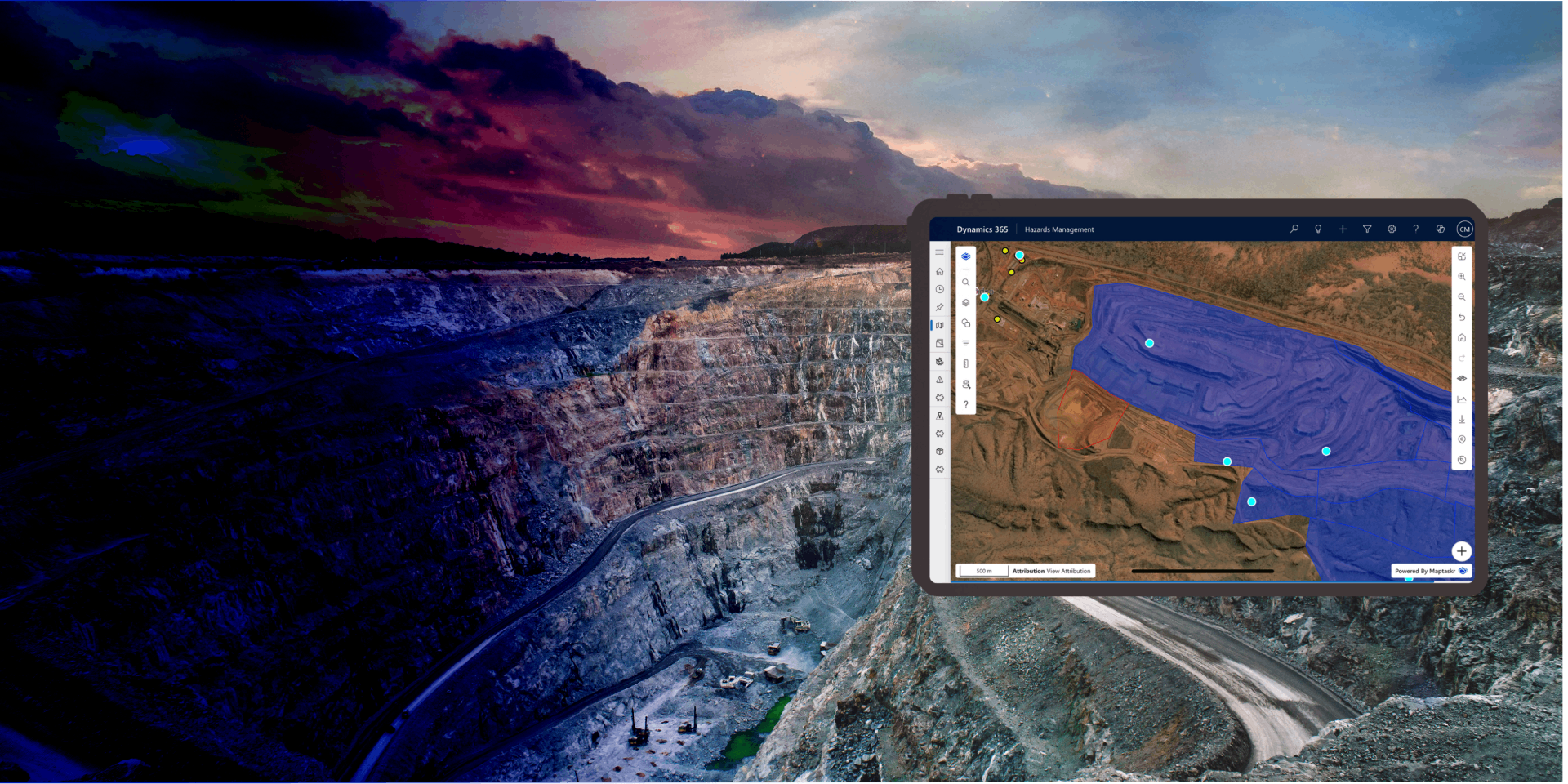
Enterprise GIS Integration
Through native integration with Esri ArcGIS Online and ArcGIS Enterprise, Power Maps supports a comprehensive range of GIS layers and open standards, including Feature Layers, Map Image Layers, Tile Layers, Vector Tile Layers, and OGC-compliant services such as WMS, WMTS, and WFS.
This integration allows teams to visualize and interact with authoritative geospatial data from ArcGIS or other enterprise GIS systems alongside business records in Dynamics 365, Power Apps, and Power Pages. Users can view, query, and edit data in context — without duplication, exports, or switching between systems.
Organizations can configure how GIS layers are styled, filtered, and refreshed, maintaining full control over performance, visibility, and security. Whether monitoring infrastructure assets, coordinating field operations, or managing environmental datasets, Power Maps ensures decisions are guided by accurate, real-time spatial information — all within the Microsoft environment.
Geospatial Authoring
Maptaskr Power Maps gives users complete control to create, edit, and manage spatial data directly within Dynamics 365, Power Apps, and Power Pages. Shapes, lines, polygons, and points can be drawn and configured to represent real-world features and operational boundaries.
All edits are securely stored in Dataverse, maintaining alignment between spatial and business data. Map layers can be styled, filtered, or validated dynamically, ensuring accuracy and consistency across every department and use case. Configurable rules define visibility, access, and editing permissions for different user roles.
From field service planning and hazard mapping to infrastructure design, Geospatial Authoring turns every map into a dynamic workspace. It empowers teams to capture spatial information, visualize changes, and collaborate more effectively — transforming location data into a living part of daily operations within the Microsoft ecosystem.
Intelligent Route Planning
Power Maps transforms how organisations plan and execute field operations with intelligent route planning powered by enterprise-grade routing services. Users can generate, refine, and optimise routes using real-world travel data, with accurate distance and time calculations delivered directly within the map experience.
By combining routing engines with Dataverse business data—such as customers, assets, and work orders—Power Maps enables routes to be planned in true operational context. Users can visualise journeys, compare options, and understand travel efficiency in a single, unified view—improving planning accuracy and decision-making.
From field service and inspections to logistics and customer engagement, intelligent routing brings greater efficiency to operations. By embedding route planning directly into Dynamics 365 and Power Platform, Power Maps enables users to move seamlessly from planning to execution—ensuring routes are not only optimised, but actionable within the systems where work happens.
AI-Enhanced Map
Whether identifying nearby customers, analyzing territory coverage, or exploring patterns in service demand, AI-Enhanced Search helps users uncover insights faster. By combining AI, context, and location intelligence, Maptaskr Power Maps enhances productivity and delivers clarity across Dynamics 365, Power Apps, and Power Pages — enabling smarter, data-driven decision-making in every scenario.
This capability bridges the gap between operational and geospatial data, allowing users to instantly locate assets, customers, or incidents without leaving their workspace. Searches can be refined using configurable filters, proximity rules, or relationship hierarchies that align with organizational structure.
Maptaskr Power Maps integrates seamlessly with your organization’s own AI services — supporting a Bring Your Own AI Agent (BYO) model through Azure OpenAI, Copilot Studio, or other enterprise-managed providers. This approach ensures all data processing remains securely within your Microsoft domain, maintaining full compliance with your governance and privacy standards.
More Features that Elevate Geospatial Productivity

Visualize, interact with, and act on your business data directly within a map-driven interface.

Connect securely to ArcGIS, WMTS, WMS, and other map service providers using enterprise-grade authentication, including OAuth2 and token-based access.

Search across Dataverse, Esri ArcGIS, and enterprise systems in real time to surface insights instantly.

Empower field teams to work without connectivity with offline maps and automatic sync on return.

Configure tailored map experiences for different business units — defining layers, filters, and display settings per role.

Style layers dynamically by attributes — using colors, symbols, or heatmaps to highlight priority.

Support global teams with localized map labels and UI — enabling seamless adoption worldwide.
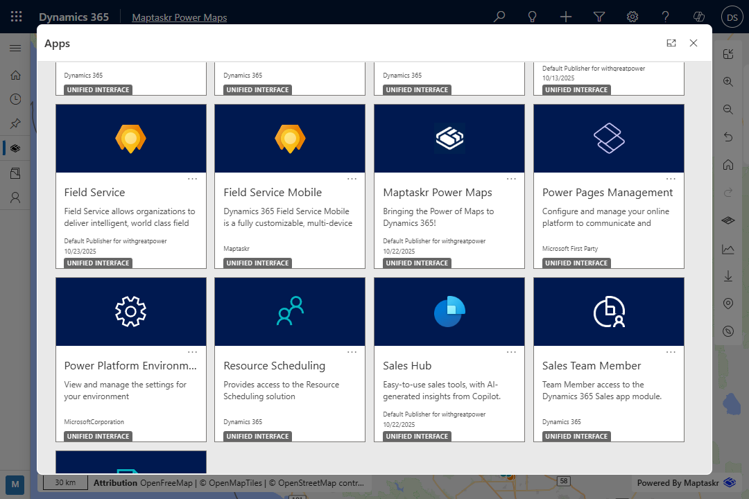
Industry-ready accelerators for Microsoft Business Apps help you go live faster and scale with confidence.